


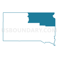
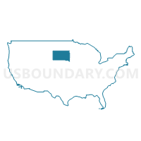
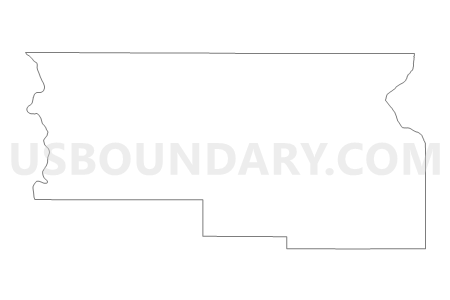
Northeast South Dakota PUMA, South Dakota
About
Outline

Summary
| Unique Area Identifier | 193970 |
| Name | Northeast South Dakota PUMA |
| State | South Dakota |
| Area (square miles) | 15,623.35 |
| Land Area (square miles) | 15,189.15 |
| Water Area (square miles) | 434.20 |
| % of Land Area | 97.22 |
| % of Water Area | 2.78 |
| Latitude of the Internal Point | 45.30813140 |
| Longtitude of the Internal Point | -98.31856120 |
Maps
Graphs
Select a template below for downloading or customizing gragh for Northeast South Dakota PUMA, South Dakota


Neighbors
Neighoring Public Use Microdata Area (by Name) Neighboring Public Use Microdata Area on the Map
- Brown, Lyon, Redwood, Chippewa, Yellow Medicine, Lac qui Parle & Lincoln Counties PUMA, MN
- East Central North Dakota--Jamestown City PUMA, ND
- Jackrabbit Region PUMA, SD
- Lakota Region PUMA, SD
- South Central North Dakota--Bismarck City PUMA, ND
- West Central Minnesota PUMA, MN
Top 10 Neighboring County (by Population) Neighboring County on the Map
- Brown County, SD (36,531)
- Brookings County, SD (31,965)
- Codington County, SD (27,227)
- Beadle County, SD (17,398)
- Richland County, ND (16,321)
- Yellow Medicine County, MN (10,438)
- Roberts County, SD (10,149)
- Grant County, SD (7,356)
- Lac qui Parle County, MN (7,259)
- Spink County, SD (6,415)
Top 10 Neighboring County Subdivision (by Population) Neighboring County Subdivision on the Map
- Aberdeen city, Brown County, SD (26,091)
- Watertown city, Codington County, SD (21,482)
- Mobridge city, Walworth County, SD (3,465)
- Milbank city, Grant County, SD (3,353)
- Sisseton city, Roberts County, SD (2,470)
- Redfield city, Spink County, SD (2,333)
- East Corson UT, Corson County, SD (2,284)
- Ortonville township, Big Stone County, MN (2,011)
- Webster city, Day County, SD (1,886)
- Groton city, Brown County, SD (1,458)
Top 10 Neighboring Place (by Population) Neighboring Place on the Map
- Aberdeen city, SD (26,091)
- Watertown city, SD (21,482)
- Mobridge city, SD (3,465)
- Milbank city, SD (3,353)
- Sisseton city, SD (2,470)
- Redfield city, SD (2,333)
- Ortonville city, MN (1,916)
- Webster city, SD (1,886)
- Groton city, SD (1,458)
- Clear Lake city, SD (1,273)
Top 10 Neighboring Elementary School District (by Population) Neighboring Elementary School District on the Map
Top 10 Neighboring Unified School District (by Population) Neighboring Unified School District on the Map
- Aberdeen School District 06-1, SD (30,759)
- Brookings School District 05-1, SD (25,450)
- Watertown School District 14-4, SD (25,013)
- Huron School District 02-2, SD (15,123)
- Sisseton School District 54-2, SD (7,853)
- Lac Qui Parle Valley School District, MN (6,541)
- Milbank School District 25-4, SD (5,743)
- Eagle Butte School District 20-1, SD (4,830)
- Mobridge-Pollock School District 62-6, SD (4,318)
- Canby Public School District, MN (3,660)
Top 10 Neighboring State Legislative District Lower Chamber (by Population) Neighboring State Legislative District Lower Chamber on the Map
- State House District 9B, MN (39,347)
- State House District 20A, MN (32,187)
- State House District 5, SD (23,721)
- State House District 3, SD (22,427)
- State House District 2, SD (21,657)
- State House District 24, SD (21,361)
- State House District 22, SD (21,252)
- State House District 4, SD (20,558)
- State House District 1, SD (20,515)
- State House District 6, SD (19,896)
Top 10 Neighboring State Legislative District Upper Chamber (by Population) Neighboring State Legislative District Upper Chamber on the Map
- State Senate District 9, MN (81,765)
- State Senate District 20, MN (66,816)
- State Senate District 5, SD (23,721)
- State Senate District 3, SD (22,427)
- State Senate District 2, SD (21,657)
- State Senate District 24, SD (21,361)
- State Senate District 22, SD (21,252)
- State Senate District 4, SD (20,558)
- State Senate District 1, SD (20,515)
- State Senate District 28, SD (19,903)
Top 10 Neighboring 111th Congressional District (by Population) Neighboring 111th Congressional District on the Map
- Congressional District (at Large), SD (814,180)
- Congressional District (at Large), ND (672,591)
- Congressional District 7, MN (625,512)
Top 10 Neighboring Census Tract (by Population) Neighboring Census Tract on the Map
- Census Tract 9514, Brown County, SD (6,228)
- Census Tract 9513, Brown County, SD (5,950)
- Census Tract 9544, Codington County, SD (5,245)
- Census Tract 9531, Grant County, SD (5,239)
- Census Tract 9543.02, Codington County, SD (5,080)
- Census Tract 9587, Brookings County, SD (4,965)
- Census Tract 9518, Brown County, SD (4,964)
- Census Tract 9545.02, Codington County, SD (4,797)
- Census Tract 9508, Marshall County, SD (4,656)
- Census Tract 9516, Brown County, SD (4,598)
Top 10 Neighboring 5-Digit ZIP Code Tabulation Area (by Population) Neighboring 5-Digit ZIP Code Tabulation Area on the Map
- 57401, SD (30,061)
- 57201, SD (24,983)
- 57501, SD (16,309)
- 57262, SD (4,963)
- 57252, SD (4,800)
- 57625, SD (4,230)
- 57601, SD (4,003)
- 57469, SD (3,305)
- 56220, MN (3,070)
- 57274, SD (2,813)